The Tsiribihina River Descent

The Tsiribihina river descent runs two or three days by pirogue from Miandrivazo down to Belo sur Tsiribihina, camping on sandbanks and passing villages reachable no other way. It is flat water rather than whitewater, and the appeal is the pace and isolation rather than any thrill. Most travellers combine it with the western circuit to Tsingy de Bemaraha.
What the Descent Involves
The trip covers roughly 150 km of river over two or three days, depending on water levels and how much time is spent at stops.
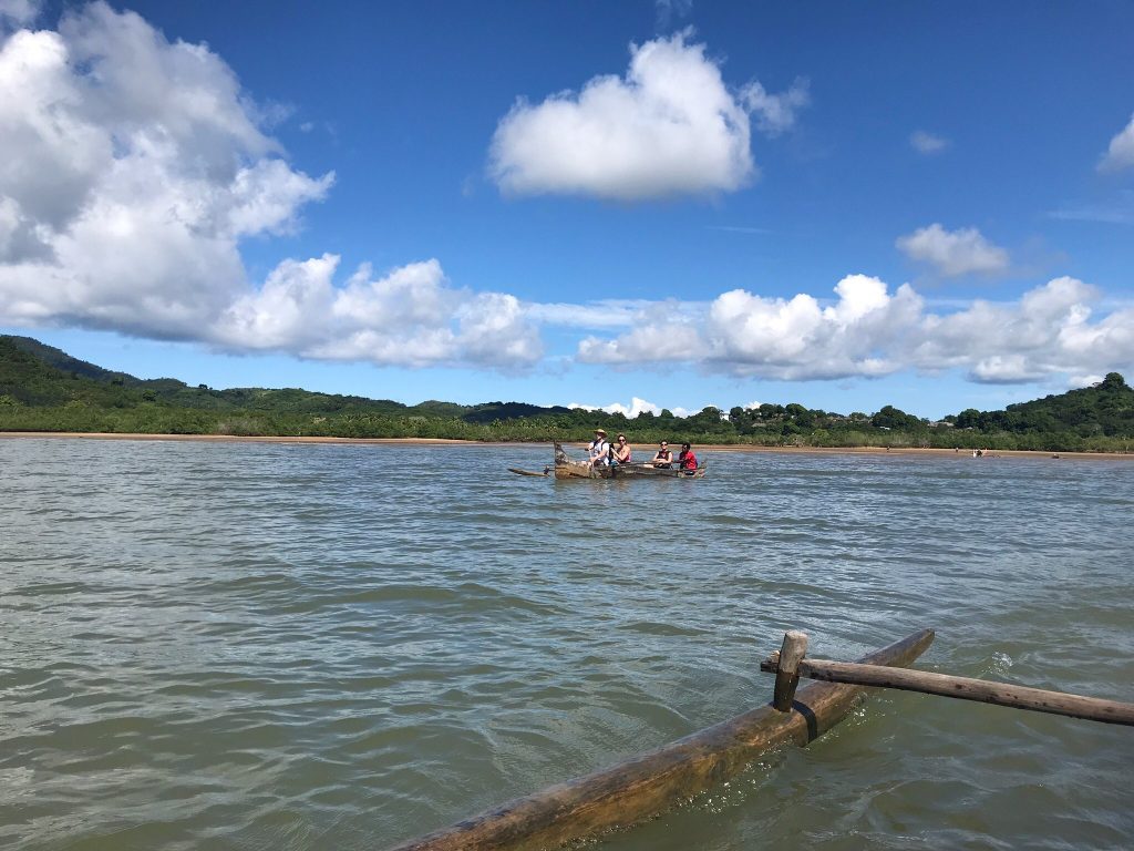
Two boat options exist. Traditional dugout pirogues are poled and paddled by local crews, slower and closer to the water. Motorised chaland barges are faster, more comfortable and considerably less atmospheric.
Nights are spent camping on sandbanks, with crews setting up tents and cooking over fires. Facilities are what you carry, which is part of the point.
The river cuts through country with no roads, passing Sakalava villages, fishermen, women washing clothes and cattle brought down to drink. Children run along the banks.
This is not an adrenaline trip. Anyone expecting rapids will be disappointed, and anyone wanting three days of doing very little in remote country will not.
A hundred and fifty kilometres of river through country with no roads, sleeping on sandbanks. The Tsiribihina is Madagascar’s classic slow trip.
Miandrivazo and Starting Out
Miandrivazo is where the descent begins, reached by road from Antananarivo in around eight to ten hours on the RN34, or from Morondava.
The town is small, hot and functional, sitting at the confluence where the Mahajilo and Sakeny rivers form the Tsiribihina. It has basic accommodation and is where trips are provisioned.
Arrangements are made in advance through operators rather than on arrival, since the crews, boats and camping equipment all need organising. Turning up hoping to find a boat is not a plan.
Draw cash before leaving Antananarivo. There is little in Miandrivazo and nothing on the river.
Most trips leave in the morning, putting the first camp within reach by late afternoon.
What You See Along the Way
The river runs through dry deciduous country that changes character as you descend toward the coast.
Wildlife along the banks includes lemurs in the gallery forest, with brown lemurs and sifaka both possible, along with crocodiles, which are present and watched for by the crews.
Birdlife is good, with herons, egrets, kingfishers, fish eagles and waders working the shallows and sandbanks. Early morning from a low boat is a productive way to bird.
Waterfalls drop into the river at points along the route, and some trips stop for swimming at pools away from the main channel.
Villages are the other half. Stops are made at Sakalava settlements where the river is the only connection to anywhere, and the reception tends to be curious rather than practised.
The Tsiribihina gorge partway down is the scenic highlight, with the river cutting between cliffs.
Pirogue, three days. Traditional dugout, poled and paddled, slower and closer to the water. The version worth doing if you have the days and want the experience rather than the transport.
Chaland, two days. Motorised barge, faster and more comfortable with more space. Suits travellers with less time or less appetite for basic conditions. Less atmospheric.
Combining with the Western Circuit
The descent finishes at Belo sur Tsiribihina, which sits on the road between Morondava and Tsingy de Bemaraha.
That position is what makes the trip practical rather than a dead end. Travellers finishing the river can continue north to Bekopaka and the tsingy, or south to Morondava and the Avenue of the Baobabs.
The standard western itinerary runs Antananarivo to Miandrivazo by road, three days on the river, then north to Tsingy de Bemaraha for two nights, then south past Kirindy Forest and the Avenue of the Baobabs to Morondava, flying out from there.
That sequence takes ten days or so and covers the river, the tsingy, the fossa and the baobabs without doubling back on the worst roads.
Vehicle arrangements need coordinating, since your transport has to meet you at Belo rather than waiting at Miandrivazo.
The descent runs in the dry season only, roughly April or May through November. Water levels drop too low late in the dry season in some years and the wet season makes the river dangerous and the surrounding roads impassable. The western circuit mostly closes from December to March, which takes the river with it. Confirm conditions with an operator before booking April travel.
Miandrivazo and the Road In
Getting to the start is part of the commitment. The RN34 from Antananarivo runs eight to ten hours through the highlands and down toward the west, and the road quality varies considerably along its length.
Most operators build the drive into the trip rather than expecting travellers to arrive independently, which is sensible given the timing needs to match the boat departure.
Miandrivazo itself is hot, sitting at low altitude after the descent from the plateau, and the temperature change from the highlands is abrupt. Accommodation is basic and the town exists as a staging post.
An alternative route comes from Morondava, driving inland rather than down from the capital, which suits travellers already on the western coast.
The RN34 also connects toward Morondava, which is how vehicles reposition to meet groups at Belo sur Tsiribihina at the end.

What to Bring
Everything you need travels in the boat, and there is nowhere to resupply.
Sun protection matters more than anything else. The river is open, the reflection doubles the exposure and there is no shade on a pirogue. A wide-brimmed hat, high-SPF sunscreen and long sleeves.
Dry bags for everything electronic, since boats get wet and camping on sand means dust as well.
A sleeping bag or liner depending on the operator, insect repellent for the sandbank camps, a torch with spare batteries and a water bottle. Operators usually supply tents and cooking.
Cash in Ariary for tips and anything bought at villages. There are no banks anywhere on the route.
Basic medical supplies, since you are days from a pharmacy and there is no phone coverage on most of the river.

The Sakalava Villages Along the River
The settlements on the Tsiribihina are Sakalava, the people who held much of western Madagascar and whose Menabe kingdom was centred around Morondava.
These villages have no road access at all. The river is the connection to everything, which is why boats stopping are an event rather than a routine.
Crews usually know the villages they stop at and the arrangements are informal. Buying something small, sweets or supplies rather than money, is the convention some operators follow, though practice varies and asking your crew is better than assuming.
Photography needs the usual courtesy of asking first, more so here where visitors are infrequent enough that nobody has developed a routine around them.
Sakalava royal tombs elsewhere in the region carry elaborate funerary sculpture, though these are not typically on a river itinerary and require permission and a local guide to visit.

Alternatives and the Manambolo
The Tsiribihina is the best known but not the only river trip in Madagascar.
The Manambolo cuts a gorge at Tsingy de Bemaraha where pirogue trips run for a half day beneath cliffs rising a hundred metres, past Vazimba burial sites set into ledges. That is a shorter and easier taste of the same thing.
The Pangalanes canal on the east coast offers boat travel from a half day to several, through lagoons and villages rather than gorge country.
The Makay massif inland from Morondava involves river sections within a larger expedition through sandstone canyons that remained largely unexplored until recent decades. Only a handful of operators run it.
For most travellers the Tsiribihina is the one to do, since it combines naturally with the western circuit and needs no specialist arrangements beyond an operator.
Frequently Asked Questions
How long does the Tsiribihina descent take?
Two or three days covering roughly 150 km, depending on whether you take a traditional pirogue or a motorised chaland and how much time is spent at village stops. Pirogue trips are typically three days, chaland trips two. Both finish at Belo sur Tsiribihina.
Is it whitewater?
No. This is flat water throughout and the appeal is pace and isolation rather than any thrill. Anyone expecting rapids will be disappointed. It suits travellers who want three days of doing very little in country reachable no other way.
When can I do it?
Dry season only, roughly April or May through November. Water levels drop too low late in some years, and the wet season makes the river dangerous and surrounding roads impassable. The western circuit closes from December to March, which takes the river with it. Confirm April conditions with an operator.
How do I arrange it?
Through an operator in advance rather than on arrival at Miandrivazo, since crews, boats, camping equipment and provisioning all need organising. Vehicle arrangements also need coordinating, since your transport must meet you at Belo sur Tsiribihina rather than waiting at the start.
What are the camps like?
Sandbanks with tents set up by the crew and cooking over fires. Facilities are what you carry. There is no phone coverage on most of the river and no resupply anywhere, so everything comes in the boat. Basic rather than uncomfortable.
What will I see?
Lemurs in the gallery forest along the banks, crocodiles which the crews watch for, and good birdlife including herons, kingfishers and fish eagles from a low boat. Sakalava villages where the river is the only connection to anywhere, and the Tsiribihina gorge partway down.
Does it combine with Tsingy de Bemaraha?
Yes, and that is the standard western itinerary. The descent finishes at Belo sur Tsiribihina on the road between Morondava and Bekopaka, so you continue north to the tsingy then south past Kirindy and the Avenue of the Baobabs, flying out from Morondava. Ten days or so covers it.
Pirogue or motorised barge?
Pirogue if you have three days and want the experience, since it sits lower in the water and is poled by local crews. Chaland if you have two days or prefer more comfort and space. The pirogue is the version people remember; the barge is the version that fits a tighter schedule.
Planning Your Trip
The Tsiribihina is Madagascar’s slow trip, and it works precisely because nothing happens on it. Three days on a river with no roads, sandbank camps and villages that see a handful of boats a season, finishing on the road to the tsingy.
Booking Your Madagascar Trip
The safari companies and tour operators listed on this website put trips like this together for a living and know which camps, guides and routes actually deliver. We are an independent guide to Madagascar; we do not book or sell tours ourselves.
When you are ready, arrange your safari, tour or holiday with one of the recognised operators listed here. Tell them your dates and what matters most, and a real person, not a form, will handle the itinerary, park bookings and logistics for you.